


Mapping helps partners understand flood risks
The question is not if Creemore will face massive flooding at some point in the future, but rather when.
Tim Koen of Aquafor Beech, the consultant who did flood hazard mapping for the Nottawasaga Valley Conservation Authority (NVCA), says the entire east side of Creemore is prone to flooding due to the annual spring freshette as melting snow and rainfall cause the Mad River to strain its banks.
“The Creemore situation is somewhat unusual,” said Koen, “because of the very wide, shallow nature of the floodplain.”
Consultants used a two-zone floodplain approach to determine a floodway where there is high risk of property damage and injury, and a fringe where flooding will be less intense in terms of depth and velocity.
NVCA undertook the Flood Hazard Identification and Mapping Program in cooperation with Natural Resources Canada and the Ontario Ministry of Natural Resources and Forestry, with the Township of Clearview providing 50 per cent of the funding.
The NVCA and Clearview Township held a Public Information Centre (PIC) on March 4 to present preliminary results and invite comment before the information is eventually incorporated into the township’s Official Plan. Kohen says residents attending PICs are typically concerned with the specific impact on their property. They often say, “I’ve lived here my whole life and I’ve never seen flooding that bad.” That may be, says Koen, but climate change is moving us ever closer to a major weather event.
Dalia Al-Ali, the NVCA’s manager of engineering services, says one of
the key findings of the mapping project is that there are significant wetlands upstream of Creemore that have major flow attenuating effects. It is essential, she says, that these areas be protected.
“The goal of floodplain mapping is not so much to mitigate potential damage as to learn how to live with the risk safely,” said Al-Ali.
The study identifies areas within the Creemore settlement that are safe from natural hazards such as flooding, and will inform future planning and development. Generally, springtime flooding is a problem at the south end of Creemore between Mill Street and Mary Street, in the fields located between County Road 9 and Edward Street and from Edward Street to Concession 3, as well as in the village of Avening.
Nine flood damage centres were initially identified by the MacLaren Plansearch watershed hydrology study. The NVCA analyzed and prioritized these centres in 2017-2018 and ranked them based on factors including flood event warning time, population impacted, affected roads for pedestrian access and vehicle access, and expected annual damages. The Mad River through Creemore ranked fifth worst for flooding risk. The Batteaux River in Collingwood topped the list, followed by the Pretty River and Silver Creek, also in Collingwood. Lamont Creek through Stayner came in at number four. Spring Creek in Alliston/New Tecumseth; Beslea Drain and Walter Creek in Shelburne; the Wye River in Elmvale and the Nottawasaga, Pine and Mad Rivers in the Angus area posed lower flood risks.
The draft study is available at www. nvca.on.ca/floodstudy. Public comment is invited before March 15.
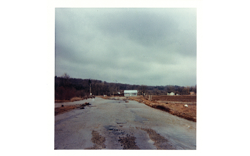
NVCA photo: Flooding south of Creemore in April of 1975
